
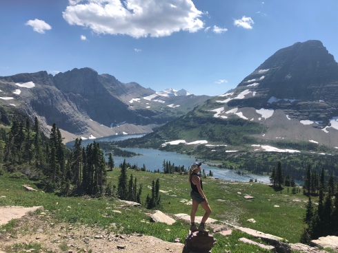
In August of 2017, I took a road-trip to Banff and Glacier with a friend. On a whim, we decided to hike the Highline Trail. Within the first mile, I told her, “This has got to be the coolest hike in all of our national parks!!” She agreed.
Seven months later, on a trip to Zion during March of 2018, I found myself at the top of Observation Point, drinking in the views after just hiking up 4000 feet of elevation gain. Despite barely being able to breathe, once again, I enthusiastically told my friends, “I think this is my favorite national park hike of them all!” Anyone seeing a pattern here?
It seems like every time I visit a new national park, I find my new favorite hike. I figured it would be fun to reminisce on some of my old trips and make a list of my 10 favorite national park dayhikes for you all! Please keep in mind that this is a running list, and I fully expect it to grow every time I visit a new national park. You have been warned.
And without further ado, Meg Hikes’ Favorite National Park Dayhikes (so far)!!
1) Highline Trail, Glacier National Park, Montana
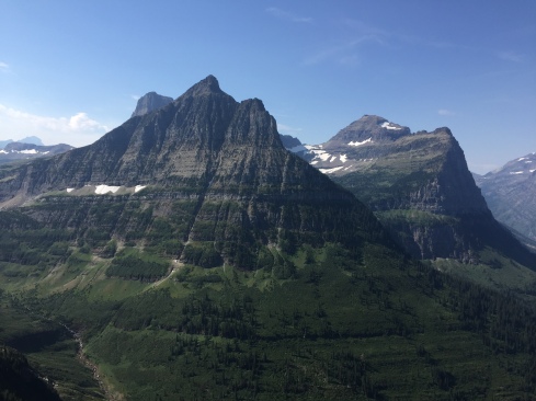
And the winner is… the Highline Trail at Glacier National Park in Montana! (Yes, I understand that there isn’t as much suspense when you start with your #1 favorite first, but the Highline Trail deserves to be listed first… it’s just that great).
I visited Glacier National Park for the first time on a 10-day roadtrip with a friend. Much like many of my trips to National Parks, I didn’t do as much research as I probably should have, and we completely winged it. As we were driving up the Going-to-the-Sun Road and neared Logan Pass, we saw a sign for the Highline Trail and figured we’d stop to stretch our legs. We packed up our bags and hit the trail. I think within the first mile I told her, “This is my favorite trail I have ever been on.” And it only got better and better.

Almost immediately, you are hiking along a cliff-face so sheer that the park installed cables for you to hold onto. I personally thought that the trail was wide enough that it didn’t make me nervous, but I could imagine holding on for dear life if you were afraid of heights or happened to hike the trail on a windy day! You are instantaneously treated to birds-eye views of the park, as the trail starts at Logan Pass and maintains its high elevation while the road descends into the valley below.

The most insane part of this trail is just the mechanics of it. It stays high above the park on the Garden Wall for miles upon miles. I’ve never been on a trail that skirts so precariously along a cliffside for so long – it feels like you are being treated to a birds-eye view of the entire park! To be honest, I feel like nothing that I could put in words would ever accurately describe the feeling of being there, perched on that ledge. This is absolutely one of those bucket-list trails that you just have to experience for yourself.

We really didn’t know how far we were going to go when we started hiking; however, the grandeur of the trail pulled us in, and we quickly decided to hike the whole 13 mile loop! Around 7 miles in, you’ll encounter a side trail – the Garden Wall Trail. This trail, while only 9/10ths of a mile, gains just over 900 feet in elevation and puts hikers at the top of the Garden Wall and Continental Divide. DO THE SIDE TRAIL. IT WAS AMAZING. From the overlook, you got to see down to Upper Grinnell Lake and Grinnell Glacier. It was also just an incredible feeling to know that you were on top of the Continental Divide. It was brutal hiking up, but you absolutely can’t miss it.

Once you get back to the loop, you’ll continue on and hit the Granite Park Chalet. We stopped here for a quick bathroom break, and then continued on down to the Going-to-the-Sun Road. Here, you will hit your elevation loss, losing about 2000 feet in 4 miles. Be sure to bring bear spray, as this section is heavily wooded and provides the perfect berry-picking environment for an unsuspecting grizzly! You’ll arrive at a shuttle stop on the Going-to-the-Sun Road, where you can hop on a free shuttle to take you back to your car at Logan Pass! Pro tip: grab a few beers, dinner supplies, and somewhere behind the visitor’s center at Logan Pass for some post-hike yoga! I don’t think I’ve ever felt so relaxed in my life… until I had to get up and walk back to the car!

2) Observation Point, Zion National Park, Utah

In March of 2018, I visited Zion with two friends. We had planned a week-long roadtrip across the Southwest and were looking to put some big miles in. I had no particular desire to hike Angel’s Landing, and because one of my friends had just done it a few months prior, we decided to hike Observation Point instead. It ended up working out really well though, because the day we arrived, Angel’s Landing was shut down to fix a broken handrail. We couldn’t have done Angel’s Landing even if we had wanted to!

The trail to Observation Point is undoubtedly tough. You gain 2120 feet in 4 miles, and 745 feet of that in the first mile. We got to the trailhead early, so the first mile was completely in the shade of the canyon walls, but I could imagine it being pretty unbearable if you got started later in the morning on a hot and/or sunny day. There was literally no shade to be found, so if you get started a little later, prepare for the heat!
As you work your way up the switchbacks of the first mile, you’ll watch yourself get further and further above Angel’s Landing, the Big Bend of the Virgin River, and the canyon floor. It really is remarkable how quickly you gain elevation during this first mile. For as steep as the trail was, I loved watching us get higher and higher above the famous Zion landmarks. It made every break to catch my breath that much more worth it! Ha..


After the first mile, you’ll start to skirt around Echo Canyon, and the trail eventually enters the canyon itself! The trail kind of takes on the shape of a slot canyon before dumping you out on the east side of the park. Once here, you’ll really start to feel like you’ve entered the Zion backcountry, even though you’ve only been hiking for a little over a mile and a half! Take in the views of the east side of the park – the environment truly is completely different and much more forested than the Valley floor.

Eventually, you’ll summit the plateau and skirt around the top of the canyon walls as you make your way over the Observation Point. Once you arrive, you are treated to Valley views as far as the eye can see. Let yourself gaze upon Angel’s Landing, the Virgin River, and the beginning of the Narrows. The views really are endless – I honestly think it is probably one of the most amazing views I’ve ever seen. We stayed up there for probably an hour taking it all in!
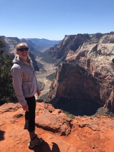
I think that another reason that I loved the trail to Observation Point so much was the diversity of it all. In four miles, you are treated to such starkly different environments; it honestly feels like you’ve walked on 5 different trails by the time you reach Observation Point. It is incredible how diverse Zion is, and only made me want to go back for more! I’ve heard that Observation Point often gets overlooked to Angel’s Landing, but if you only have time for one hike in Zion, I would absolutely recommend Observation Point!
3) Grinnell Glacier Trail, Glacier National Park, Montana

We hiked up to Grinnell Glacier the day after we did the Highline Trail. We had a few hikes in mind for that day, but the second that we saw Grinnell Glacier from the overlook on the Garden Wall, we simultaneously said to each other, “We have to hike that tomorrow.” It was decided. And oh, it did not disappoint.
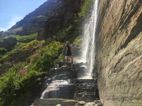
If you are staying on the westside of the park, the ride to get to the trailhead is a bit of a haul. You have to drive the entire Going-to-the-Sun Road to the east side of the park, actually leave the park, and then drive north to Babb, Montana to entire the park once again. The entire journey will probably take you 2.5 hours, depending on traffic. It is totally worth it, but if you are looking to get to the trailhead by a certain time, don’t forget to budget for the long ride.

The hike up to Grinnell Glacier is about 9.7 miles roundtrip, with a total of 2040 feet of elevation gain. Upper Grinnell Lake was quite possibly one of the most peaceful places that I have ever been. After we explored the lake a little, we sat down for a snack and a summit beer, and I ended up falling asleep for about an hour! I can honestly say that I have never taken a nap on a hike before or after my hike to Grinnell Glacier. It was incredible.
Another reason why this is one of my top favorite hikes is because we could see the lookout on Garden Wall that we had hiked to the day before. It was so cool to have arrived from the other side of the park to see the exact location that we had hiked to from a completely different vantage point. Also, while the view of Upper Grinnell Lake and Grinnell Glacier from the Garden Wall Lookout was beyond beautiful, it was just as fascinating to see it up close in person.

Grinnell Lake was just as beautiful and milky as Upper Grinnell Lake, but was a much deeper turquoise. Despite the high mileage and elevation gain, you have plenty of views to take your mind off of it. Once you hike past Josephine Lake, the trail starts ascending up to Upper Grinnell, and you are treated to views for as long as the eye can see. If you aren’t up for such a long hike, however, there is a water taxi that will take you the length of Josephine Lake and back, shaving a little over 3 miles off of your hike!

One last hot tip: if you do decide to hike to Grinnell Glacier, do yourself a favor and stop at the Two Sisters Cafe in Babb for some huckleberry pie on your way home. Trust me on this one.
4) Four-Mile Trail to Glacier Point, Yosemite National Park, California
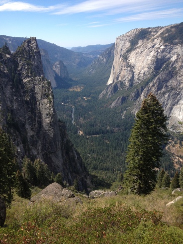
Picture this: it is your first time in Yosemite, you have done zero research on hiking in the park, and you have absolutely no idea what to expect. You and your friend (ironically, the same friend who you spontaneously hopped on the Highline Trail with… could there be a pattern emerging?) see a sign for a “Four-Mile Trail” and figure, sounds pretty moderate. Within a tenth of a mile, the trial starts climbing up towards the top of the valley, and 4.8 miles later, unbeknownst to you, you arrive at Glacier Point after climbing 3200 feet. Sounds like a good time, right?

It was an amazing time!! The trail gives you spectacular, ever-changing views of the entire valley, where you can gaze upon Yosemite Village, El Cap, Half Dome, and Yosemite Falls from above. The switchbacks are moderately steep, but are still gentle on the knees. And yes, you can drive to Glacier Point, but isn’t it so much more rewarding know that you HIKED there from the VALLEY FLOOR? Answer: yes, yes it is.
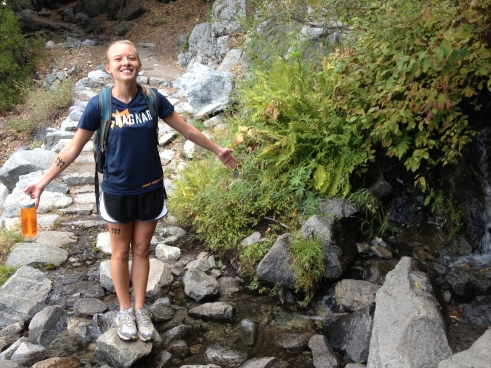
Please keep in mind though that this hike, albeit absolutely beautiful, is an absolute beast. The numbers say it all – 3200 ft. in 4.8 miles is no joke. When my friend and I hiked it, we were on our way home from a Ragnar Relay (hence me turning into a walking Ragnar Relay billboard, pictured above) and were in great shape – and it still kicked our asses. If you are planning on doing this hike, please come prepared. What comes up must come down, and there are no midway exit routes if you decide to bail out halfway up the trail. There were a few water sources along the way, but they seemed a bit unreliable if you hike in late season, so pack enough water the entire day (water available at Glacier Point in the summer only). Keep in mind that there are no free shuttles from the top of Glacier Point down to the Valley; there are only three guided tour buses a day that can take you back down to the Valley for a fee (if they aren’t already full). Unless you plan ahead and park a car at the top or arrange someone to pick you up, you’ll likely have to hike back down the way you came, making the Four-Mile Trail into a 9.6 mile trail.
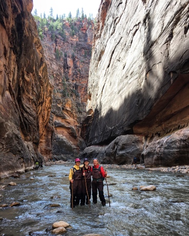
5) The Narrows, Zion National Park, Utah

The Narrows had been on my list for a long, long time before I was able to hike them on my March southwest roadtrip. We did the Narrows the day before tackling Observation Point, and it quickly became one of my favorite hikes ever! To get to the Narrows, you have to first hike the easily-accessible, mile-long Riverside Trail. At the end of the Riverside Trail, the trail vanishes, and your hike through the slot canyons of the Virgin River begins!

Since we did the Narrows in March, the water was still pretty cold. We elected to rent the full Dry Bib package from Zion Outfitters, so there was no chance of us getting wet. Because we were so early in the season, we pretty much had the river to ourselves. It was incredibly peaceful and was such a unique experience! The Narrows go on for 10 miles, so you can hike in as far as time allows. As you go deeper and deeper, the slot canyons get more and more narrow. By the time we turned around, the river was only about 6-7 feet across! For lack of better terms, it was honestly just so cool to be back there.

Hiking upstream took us a lot longer than expected. Not only are you battling the current, but you have to take your steps a lot slower to make sure that you have proper footing on the riverbed. Hiking downstream was a breeze, though. I think it took us about 2 hours to hike 3 miles in against the current, and less than an hour to hike back downstream! It felt like we flew!!
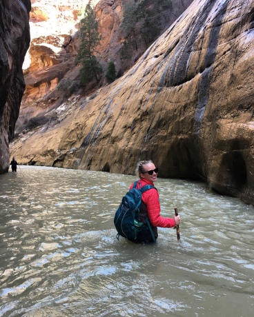
If you choose to hike the Narrows (which you should all do if you are visiting Zion), be sure to watch the weather. If there is any chance of rain, don’t hike them. The canyon walls are extremely steep, and if a flash flood were to rage down the canyon, you’d have no choice but to be swept up in it. Many people have lost their lives to flash floods in the Narrows – be smart and know your (and the weather’s!) limits. Also, if the snowmelt is too high during Spring, the park can close the trail to hikers. Remember that this is for your safety, and always abide by the rules and regulations that the park enforces.
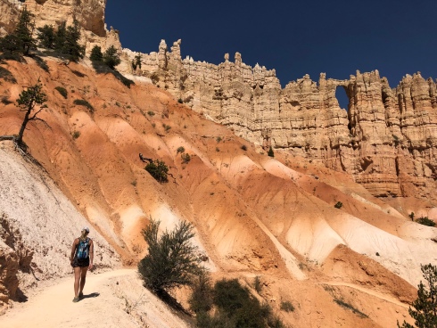
6) Peak-a-Boo Loop, Bryce National Park, Utah

Okay, everybody. Repeat after me: If I go to Bryce Canyon, I will hike the Peek-a-Boo Loop. Regardless of if you have 3 hours or 3 days at Bryce Canyon NP, the 5.5 mile Peek-a-Boo Loop trail is a can’t-miss. CAN’T. MISS.

I think the reason why I loved the Peek-a-Boo Loop so much was that it really showed off the diversity of the park. The trail starts on the canyon rim, so you begin by looking down at the Hoodoos. As soon as the trail begins, however, you rapidly descend down into the Hoodoos and are soon at eye-level with the tops of the Hoodoos in the amphitheater. This is an incredibly unique perspective, but one that you really can’t appreciate until you actually experience it for yourself.

Once you’ve taken a moment to appreciate how unique it is to be eye-level with the Hoodoos (or stopped for long enough to think to yourself, “Why was meghikes rambling on about how special this is??” – either or, really), you start descending below the Hoodoos. You get up-close and personal with the Hoodoos, and it allows you to truly take in how intricate these rock formations are. The trail descends down into slot canyons and through tunnels, and its hard to discern which are manmade compared to those that are completely natural.
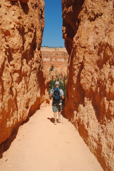
The environment of Bryce Canyon is absolutely fascinating, in that it feels like it is constantly changing around every bend. This hike will take you from the top to the bottom of the canyon, through red Hoodoos and whitewashed walls, on top of tye-dye sand mounds, and among ponderosa pines. One minute you’ll feel like you are in the middle of the desert, and the next, you’ll be surrounded by an alpine forest. Next time you find yourself in Bryce Canyon, remember your promise and hike the Peek-a-Boo Loop trail!!
7) Ryan Mountain, Joshua Tree National Park, California
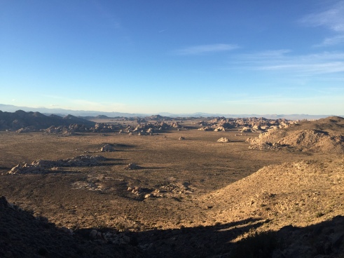
You guys. You probably don’t need me to tell you this, but I’m going to tell you anyway. JOSHUA TREE NP IS SO COOL. LIKE SO COOL. Now, I’m a desert lover as is, but I’d honestly be surprised to find anyone who has visited Joshua Tree NP and not thought it was cool. Like so cool.

For those of you who have not been to Joshua Tree, you might be asking, but why is it cool? Like so cool? WELL LET ME TELL YOU. There are JOSHUA TREES everywhere, which makes you truly feel like you are on the moon, if the moon had Joshua Trees. Regardless, the trees dotting the barren landscape really does feel otherworldly. Where the landscape isn’t barren, it’s filled with huge rocks, making the park into a rock climber’s dream.

The hike to Ryan Mountain, the second tallest peak in the park, is only 1.5 miles each way. Don’t be fooled by its low mileage though; the trail gains 1200 feet of elevation in those 1.5 miles, and you are in for quite the climb.
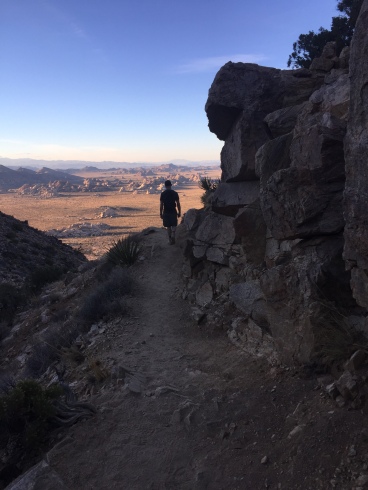
The cool thing about Ryan Mountain is that it is located pretty much smack-dab in the middle of the park. It’s the highest peak in the immediate vicinity, so you truly are treated to 360 degree views of the entire park. It is amazing to see just how many Joshua Trees dot the desert floor beneath you, and to see how small they look from 5457 feet up! The view from the summit also shows you just how remote Joshua Tree NP is – it was crazy to see just how much of the park was inaccessible by car. I loved seeing just how protected the land really is!
8) Emerald Lake, Rocky Mountain National Park, Colorado

In May of 2017, two of my friends and I decided to go to Colorado for a girls trip. We planned to stay at a campground in Rocky Mountain National Park and spend all five days of our trip hiking. Now, I’m not sure if we were just talking to the wrong people, but not a single person told any of us this golden tip that I’m about to tell you now: Maybe don’t go to Colorado in mid-May. Okay, okay. Let me start over… Colorado in mid-May is beautiful – I mean, Colorado any time of the year is beautiful. But mid-May is also very much between seasons, which shows on the trails and in the weather.

Our first full day in Colorado was absolutely beautiful; a perfect Spring day. We heard rumors of a snowstorm moving in, but the skies stayed so clear that it was hard to believe. As we left the campground on the morning of our second day, however, a ranger stopped our car to tell us that a storm was moving in, they were expecting about 2-3 feet, and if we chose to stay in the campground that night, the plow probably couldn’t get to us for a few days. Our campsite was about 2 miles down a dirt road, and, as much as we hated the idea of cutting our trip to RMNP short, the thought of getting stuck down a dirt road for a few days wasn’t too enticing either. We ended up packing up camp, moving camp down to a park in Denver, and still waking up to about 4 inches of snow in town! The park got their promised three feet, and we were very thankful for the ranger that encouraged us to pack up. Moral of the story: if you plan a trip to Colorado in mid-May, have a back-up plan prepared. Trust me.

Anyway! This blog post is not about failed trips to beautiful national parks – it is about my favorite dayhikes! On our first day in Rocky Mountain National Park, we hiked up to Emerald Lake. Considering it was mid-May, the trails were still covered in snow. None of us had microspikes, so it took us longer than normal to hike the 3.6 miles to Emerald Lake and back.

If you are looking for a shorter, easily accessible trail in RMNP, look no further! In only 1.8 miles, this trail takes you past three alpine lakes (Nymph, Dream, and Emerald), and all the way up to over 10,000 ft.! The trailhead begins at Bear Lake at 9475 feet, and Emerald Lake sits at 10,110 feet, so the elevation gain is pretty mild. Once you get to Emerald Lake, you’ll be surrounded by 12,000 foot granite peaks and inviting glacial water. Of course, we went in mid-May, so the lake was still frozen over. Still absolutely beautiful, and a great introduction to snow-hiking!

9) Hidden Lake Lookout, Glacier National Park, Montana
Now, you might be thinking, a third hike in Glacier National Park? Yes, a third hike. Glacier is just that beautiful. And the trail to Hidden Lake Lookout is no exception!

The trail to the Hidden Lake Lookout also starts at Logan Pass, behind the visitor’s center. While the hike is always beautiful, it is exceptionally perfect if you don’t have a lot of time to spend hiking that day or if you are bringing children. The hike itself is only 2.7 miles roundtrip, and virtually the whole trail is on elevated boardwalks.

If you choose to hike to the Hidden Lake Lookout, keep in mind that this one of the most popular trails in the park, likely due to its low mileage and easy accessibility. Don’t be fooled by the picture above – we shared the boardwalk with no less than 1,000,000 other hikers that day. If you are looking for solitude, I would highly advise finding another trail.

That being said, Hidden Lake Lookout is an absolutely beautiful trail. In the summer, the trail is surrounded by wildflowers, and you are able to see many of the peaks up-close and personal. This area is also very popular with wildlife, so you’ll likely encounter a few mountain goats on your quick jaunt up to the overlook! The view from the overlook is magnificent as well – after hiking only 1.4 miles, you truly feel like you are in the backcountry of Glacier! The lake is massive, and Bearhat Mountain rises up and out of it so dramatically. You can even see Lake McDonald from the overlook!

Once you get to the overlook, even if you aren’t planning on hiking down to the lake itself (another 1.4 miles), continue along the trail for a bit of solitude. Our final destination was the overlook, but we wanted to eat lunch with a view of Hidden Lake. We continued down the trail for probably a tenth of a mile, and were so surprised to see that basically EVERYBODY stopped at the overlook itself. We had a nice lunch spot all to ourselves, where we were able to appreciate the peaks and lakes around us.
10) Mammoth Hot Springs Terraces, Yellowstone National Park, Wyoming

I was a little hesitant to put this one on the list, since it technically isn’t a “hike” per se, but rather a long walk on a boardwalk. But the Mammoth Hot Springs Terraces are just as cool as every other hike on this list (and might possibly be the most unique!).

The boardwalk covers about 1.75 miles and has about a total of 300 feet in elevation gain. We visited the Terraces with a looming thunderstorm threatening to break out at any second. Fortunately for us, we only got sprinkled on a few times, and were able to take some amazing pictures with the extreme weather! It made the whites, reds, grays, and blacks of the hot springs even more vibrant. The two pictures above were taken in the exact same spot, only seconds apart; one was taken directly to my right, and the other directly to my left. The weather was no joke!

Even if you visit the Terraces without extreme and inclement weather, you are in for a treat! The travertine formations are SO UNIQUE, and each one takes on a life and form of its own. The formations range from the purest of white to the deepest of black, with almost every other earthy color you can think of in between! Bright red, rusty orange, vibrant yellow, pale blue, chocolate brown… the colors of the hot springs are just as impressive as the intricate formations themselves.

We walked along the entire boardwalk on our visit; no board was left unturned! We parked at the lower parking lot, and started out by going counter-clockwise and up the hill. We (read: I) thought that the boardwalk made a loop, but it dead-ends at the top of the hill at Angel Terrace. We doubled back, but took a different boardwalk back down to our car, finishing the loop on the lower terraces.
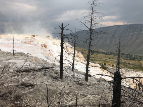
Regardless of whichever parking lot you park in, or which boardwalk you start on, you really can’t go wrong as long as you make sure to visit every spring. Each of the formations were completely different, and each warranted a visit. Aside from the hot springs, you are treated to expansive views of the surrounding valleys and Mt. Everts. Although the boardwalk is only 1.75 miles, we were up there for over an hour because we stopped so much. If you find yourself in Yellowstone, you can’t miss taking a walk along the Mammoth Hot Springs Terraces!

amazing!! great post! thank you
LikeLiked by 2 people
Great shots! These hikes are incredible. I’ve done all of these but Glacier, which I’ll be working on this summer with Americorps and the conservation corps. Looking forward to it! Your photos are great.
LikeLiked by 1 person
Thank you! Enjoy Glacier, you’ll love it!
LikeLiked by 1 person