
On our second day of our three-day Havasupai adventure, we followed Havasu Creek all the way from the campground down to where it converges with the Colorado River. The turquoise waters of Havasu Creek and the murky waters of the Colorado River meet in such an abrupt fashion, leaving one to think that they will forever stay separated. It truly is a sight to see!
When we first started researching our Havasuapi hike, we were inundated with pictures of dreamy blue waterfalls, pastel creeks, and bold inflatable flamingo blow-up floats. One of the pictures that kept popping up (which, I’m sure you’ve all seen on travel instagrams everywhere) is a picture of a girl on a standup paddleboard, floating through a bleached slot canyon. Finally, after days of instagram geotag* searching, I finally discovered that the picture wasn’t taken near the waterfalls whatsoever, but down where Havasu Creek converges with the Colorado River. After a little bit more research, I realized that the magic of the confluence wasn’t necessarily the slot canyons nearing the edge, but rather the colors of the two waters converging.
(*Side note – I know there is a lot of debate going on about the negative effects of instagram geotagging, but I find it to be SO helpful in planning hikes! If I’m planning a hiking or backpacking trip to some place I’ve never been, I rely on instagram geotags more than google searches! Also, I find them to be super helpful for trail reports, snow conditions, and campsite locations! I get it – more people to a certain location = more impact on the environment. But shouldn’t we be encouraging people to enjoy the outdoors and, especially in this political climate, encourage advocacy for protecting our public lands?)
Anyway, after a bit of research, we learned that the hike to the confluence was a 16-mile roundtrip day hike from the campground. For the most part, the trail was relatively flat, and followed the river.
We actually didn’t decide to hike to the Confluence until the day before we were leaving on our trip. The thought of hiking 10 miles in, going on a 16 mile day hike, and then hiking 10 miles out the next day sounded quite daunting. But two days before we were supposed to leave, I texted the group, “I think I want to hike to the confluence,” and both of my friends instantly agreed! It was decided! We’d be using our one full day down in the canyon to hike to the confluence!
The first task of the day was descending down to Mooney Falls. Tip #1 for descending Mooney safely – send a friend down to check it out first!

To be totally honest, the descent down to Mooney was as terrifying as I expected it to be. Usually, I make it a point to build up things in my head that I’m anxious about, so that when I encounter them, they aren’t as sketchy as I anticipated. Mooney, however, was different. The ladders were soaked from mist, which I expected, but they also protruded from the rock by at least a foot in a few spots, so you had to figure out how to shift your body weight from wet rock to wet ladder. Slowly, we made our way down to the bottom of Mooney, and my feet were never so happy to hit solid ground!
Tip #2 for Mooney – just take it slow. The ladders and rocks are a lot more stable than they seem. Just make sure that you have comfortable footing before shifting your body weight. And remember, going down is always worse than coming up!

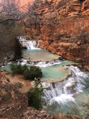
Once we got down to Mooney, we took a few minutes to take in the enormous wall of water protruding from the desert rock. It truly was incredible.


After leaving Mooney, the trail takes you slightly uphill. We had a bit of trouble finding the trail, as there were thousands of side trails going every which way. All of the trail reports that we had seen just told us to “follow the river and you’ll be fine.” For the most part, that was absolutely true; for this part of the hike, not so much. We tried to stay close to the creek, but all of the trails that led to the creek were ending at picnic spots. My advice for this section – stay high. You’ll eventually be forced to take a trail uphill, as cliffs start to form a bit, and I think the immediate high trails offered a bit more clarity than the maze of trails that bordered the creek.

Eventually, the trail will take you back down to the creek, and starts to weave back and forth through the water. Other than the confluence itself, this was definitely my favorite part of the trail. The water was so peaceful and calm, and offered a refreshing respite from the heat! The reflection of the red canyon in the tranquil water was unlike anything I had seen before; it was honestly hard to conceptualize the fact that these pastel colors were completely natural! I could have stayed at these creek crossings all day.


From left to right: Tevas, River Things, Selfie Stick* (*temporary trail name; permanent trail name tbd).

A lot of the trail reports that we read mentioned that the trail was hard to find in some places when it crosses the creek; however, we found them to be pretty straight-forward. Whenever it was time to cross the creek, the trail clearly ended right at the water. A few times, it took us a bit of searching to find the trail on the other side, but, for the most part, there was always a cairn or a clear exit on the other side.
After crossing the creek a few times, you’ll hit wild grape fields! Going in early spring, they were pretty brown; but I imagine when they bloom, they must be absolutely gorgeous! (Do grape fields bloom? I actually have no idea. In my mind, they are a tye-dye of deep green and deep purple!)

For a minute there, you’ll alternate between being surrounded by grape fields and kissing the creek. Lots of grape fields, lots of stream crossings.

Hilariously enough, we also had no idea just how grand Beaver Falls were. We had seen pictures, so we had a general idea that they were pretty big, but there were numerous falls along the way that we all agreed could potentially be Beaver Falls.

You are pretty – are you Beaver Falls? No? Okay… moving on.

And I thought the ladders were done at Mooney… ha!
Finally, the canyon will open up, and the grandness of Beaver Falls will leave you awestruck. We got to the falls by 9:30am and had them all to ourselves!

*side note – there is actually a sign at Beaver Falls telling you that you made it. Just a lil FYI for when you are wondering if the not-so-grand-but-still-ridiculously-gorgeous waterfall in front of you is Beaver Falls or not…
(Above, Beaver Falls when we came back up from the confluence)
When you leave Beaver Falls, stay as high as you can! There is a side trail that will take you down to the falls themselves, but go all the way back up to the trail that you came from and continue along the cliff to get down to the confluence. We took this way on the way down, but got a little lost on the way back up and had to scramble down a little cliff face in order to get down to Beaver Falls again. I mean, it was completely doable, but the high route is much easier.
After staying high on the cliff, you’ll come across some switchbacks that lead you down to the creek. The trail is very clearly marked on the way down, but not so much on the way back up. Try to make a mental note of where you came down. Only one person in our group of three noticed the trail on the way back up – I would have completely missed it had she not pointed it out!

Once you make your way down the switchbacks and get to the creek, the trail is pretty straight-forward. You cross the creek quite a bit, and come across beautiful swimming holes along the way!


A few hikers that we had been leap-frogging told us that the canyon makes a sharp zig-zag near the end of the hike. Nearing the end, I think we were all just ready to be there, and so every turn of the canyon seemed like a zig-zag! I think a better determination of when you are almost there is when you go through the tunnel. I didn’t grab a picture of it, but it is extremely apparent. Once you go through the tunnel, you are basically there!
The tunnel will leave you pretty high above the river, so you’ll have to scramble down the cliff and get a bit wet to get to the confluence! Once you drop off your packs, the creek gets shallower, and the magic of the narrow canyons will leave you speechless!
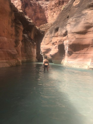

Here is the most narrow point of the canyon. I heard from quite a few people not to swim out through the hole, as the current could sweep you out to the Colorado River; however, while we were there, a bunch of different people were doing it! We decided not to do it, but as long as you are a fairly strong swimmer, I think you’ll be fine.

Considering how much solitude we felt on the hike down, I was really surprised to see a ton of people down at the confluence! We couldn’t have seen more than seven people on the way down, but there had to be at least thirty people down there enjoying the sun! I didn’t see any rafts, so I assume that most people hiked down. It was super surprising!

We played around in the narrow canyons for a bit, but I desperately wanted to see the two rivers converge. It was clear that you had to get yourself onto the cliffs on the right side of the picture (above), but there was no obvious¢ß f trail. It took awhile for me to find the entry point, but if you travel upstream enough, there will finally be an accessible spot. Seriously, just keep going upstream as far as you can. You’ll eventually be able to climb up there!
And boy, was it MAGICAL.

I truly don’t understand how the color in the two waters stay so separated – I expected more of an ombre effect. This was 10x more amazing than I could have ever imagined.

It was also just extremely cool to be down so deep in the canyon! I’ve been to the Grand Canyon loads of times (NAU represent!), but never to the bottom of it. The Colorado River truly does have such a intimidating power. It’s no wonder this bad boy was able to carve one of the most beautiful, intricate, and impressive canyons in the world!

On account of having to hike 8 miles back to camp, we weren’t able to spend much time down at the confluence. I’m looking forward to spending more time with the mighty Colorado in the future, and discovering more of her secrets!

The hike back up was just as beautiful; the views were completely different, and we found ourselves marveling at the intricacies of the canyon walls around every corner!

Mountain goats! So, funny story – on the way down to the confluence, we happened upon a hiker that we had been leap-frogging throughout the day standing in the middle of the trail. As soon as he saw us, he immediately put his finger up to his mouth as to “shush” us. The urgency in his act (and the expression on his face) made my heart briefly stop. All of the fears that I had been suppressing about deadly rattlesnake attacks + no cell service immediately flooded my thoughts, and my heart began pounding like no other. We inched up to him, and he whispered, “Mountain goats!” A herd of seven mountain goats were chilling in the middle of the trail!
Eventually, the lone hiker made the decision to inch his way across the trail. Normally, I wouldn’t be afraid of mountain goats, except for one teensy problem – a baby goat was on one side of the trail, and what I assumed to be the mama mountain goat was sitting on the other. Now, I’m not sure if I would call myself an “expert” hiker in any sense of the word, but I have enough common sense not to get between a mother wild animal and her baby. He made it across (with death glares from mama – I have to say), but there was no way we were about to try that stunt.
We were stuck! Eventually, a group of five hikers happened upon us, and made the same decision not to get between the mama and baby. As we were standing there, however, the goats clearly started to feel threatened by our big group, and all stood up, made a little pack, and began acting a bit more aggressive towards us. We took their cue and headed back up the trail to assess the situation. One of the hikers called it, and ended up forging a path through the vegetation to get down to the river and go around the goats. Fortunately for us, however, when the goats got together in their little pack, the baby crossed the trail to be with its mother.
Another one of the hikers decided to test it out, and slowly passed the herd in their new spot. The goats didn’t act nearly as aggressive (but still gave their fair share of death glares!), and we were all able to use the trail and get past them one-by-one! Now, I know what you are thinking, “Come on, Meg, they were just mountain goats!” But hey! Wild animals are wild animals! We were very relieved to see that they had crossed the river and taken up a new spot to silently judge us as we hiked back up to the campground!

Although I didn’t recognize most of the views on the way back, I was extremely surprised to see this cathedral-looking canyon wall staring down at us. Surprise! This is where you scale the rock in order to get back to the switchbacks (will be on the left side of the canyon) that I absolutely did not recognize. Before realizing where the trail was, we watched another hiker march upstream, so I’m assuming that most people get a little lost here. Don’t fear though – we saw him again, so he made it out!


Once you get to this sign, stay high! This is where we ended up descending back down to the creek and going a completely different way than we came down. Also, we arrived a little late, but from 9 – 5ish, a member of the Supai tribe sits here to check that you have your wristband in order to enter the reservation.
After the trail takes you back down to the river, you’ll cross it a few times, and then arrive back to the wild grape fields. Once you pass the fields, if you stay high, the trail is pretty straight-forward going back.
A few things to end on:
- I would highly highly recommend investing in a good pair of water shoes to hike down in. I was originally planning on just wearing an old pair of running shoes, in order to save my hearty hiking boots from a certain watery death (10+ creek crossings in those bad boys? No thanks!). A few days before leaving, however, I texted both of my friends to ask them what they were planning on using, and both of them said water shoes. I impulsively went to REI, tried on about 8 different pairs of water shoes (so sorry REI employee), and had an internal/external struggle about whether to pull the trigger and invest in some water shoes – ya girl is on a major budget right about now! My mom, my fears, and the trusty REI employee eventually convinced me to buy a pair, and I was SO GLAD I did. I ended up going with the Keen Whisper Sandals (which, actually, ended up not being too bad thanks to some surprise dividends in my account – dear lord, I love REI). They held up extremely well, dried quickly, and helped me avoid taking off my shoes at every river crossing. I also think that trudging around for 16 miles with soaking wet shoes would have been pure hell. They were truly a lifesaver. Don’t believe me? Just ask my badass bestie, “Tevas,” just exactly how she earned her trail name on that 16-mile hike. Luv u Tevas.
- When you aren’t crossing the creek, a lot of the trail is surrounded by bushes. One of the hikers that we encountered was extremely concerned about our bare legs (we were all wearing shorts), and even offered to let us borrow his jacket to cover our legs with. We politely declined, and the bushes ended up being totally fine. Said hiker was wearing zip-up pants (which, if you are sensitive to the bushes, are an awesome choice), but at every single creek crossing, he had to sit down and take them off. I was a little nervous about ticks, but consistent tick checks did not turn up any little bastards. I will say though, at the end of the day, all of our legs were slightly burning. We all thought that it must have been a sunburn, but looking back on it, I’m wondering if the mixture of whatever oils were on the bushes and the minerals in the water might have had something to do with it. I mean, it wasn’t painful, but as we all put on pants when we got back to the campground, it was relatively noticeable. Just something to think about!
- I was pretty nervous about rattlesnakes, but we did not see any. I’ve heard spring is usually the time when all of the babies come out to play, but we might have been a little too early. There were a few spots where the brush was really thick, in which I though, “man, this would be the perfect place for a rattler to hide out,” but the beauty of the canyon distracted me for the most part. Maybe this would be another reason for pants?
All in all, the hike down to the confluence was SO unique and absolutely beautiful. I would highly recommend it! The hike back up did not seem half as long as the hike down, and it really was pretty flat for the most part. We couldn’t go as fast as we usually hike, on account of the river crossings, having to find the trail, and fatal mountain goat deathtraps, but we were done by 5! I will say though – we all agreed that it would have been nice to lounge by the falls for a day; however, the magic of the confluence is something that I would never ever take back.
If you have any questions whatsoever about the confluence, please comment here or email me at meghikes1@gmail.com! I had quite a few questions that I wish I could have asked somebody, so please don’t be a stranger!
Happy Trails!
